
NEWS
Himalayan Glacial Flood Risk Outran Nepal’s Lake Maps
After Nepal’s ice-rock collapse killed 1,355, a UN official said millions sit downstream of Himalayan glacial floods that lake sirens still miss.

A senior UN official said millions of people sit in the path of Himalayan glacial floods, after an ice-and-rock collapse in Nepal killed 1,355 people.
Kanni Wignaraja, an assistant secretary-general who also directs the UN Development Programme in Asia and the Pacific, said the population at risk “goes into the millions,” citing figures her office compiled with partners in June.
A Glacier on Langtang Lirung Failed at 8:37 a.m.
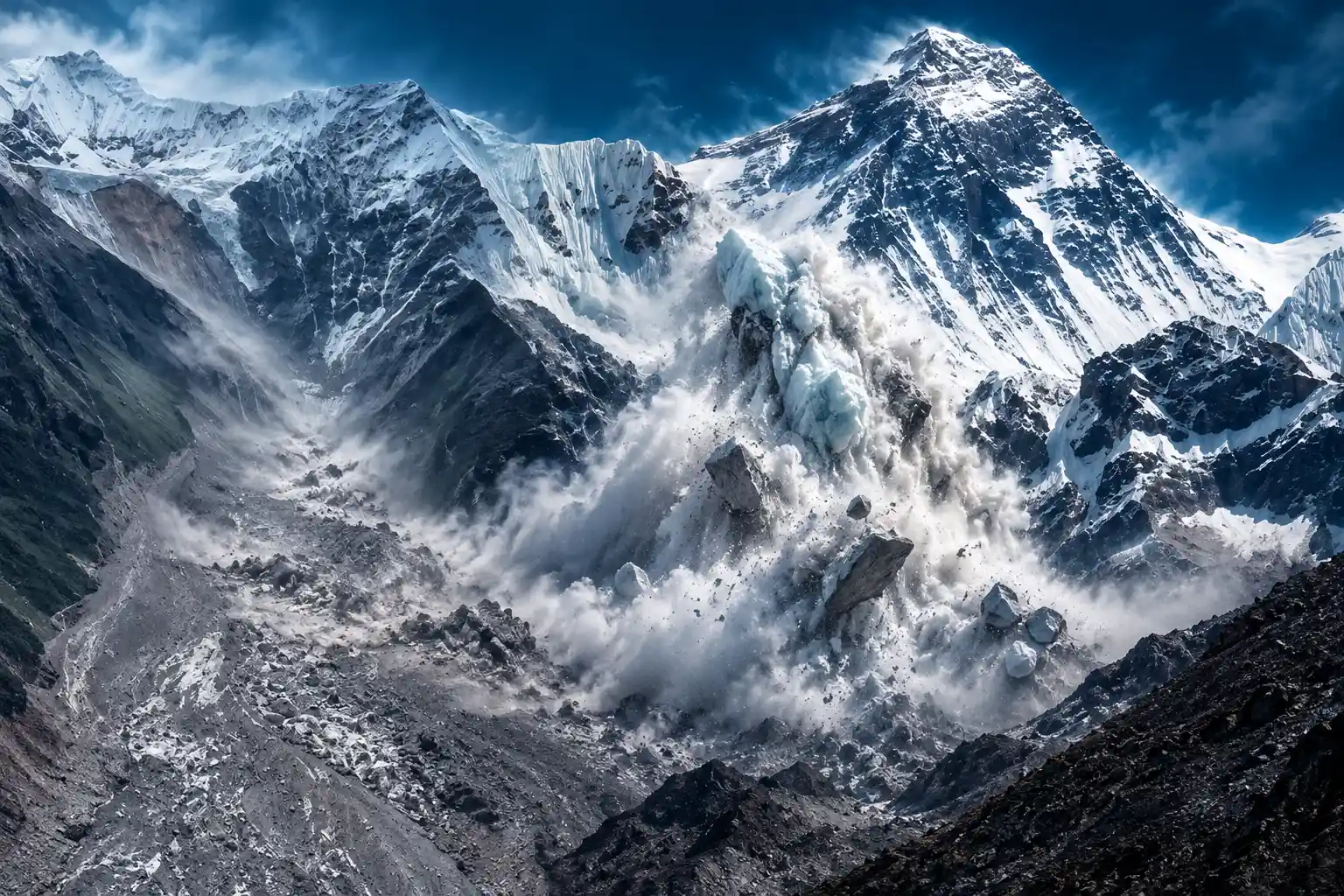
On the morning of August 26, a slab of ice and rock broke from the north face of Langtang Lirung, a peak on the Nepal-Tibet border, and fell about 1,200 meters into the valley. Daniel Shugar, a geologist at the University of Calgary, put the failed mass at about 0.2 square kilometers, coming away near 5,200 meters above sea level.
The United States Geological Survey read the shaking as a magnitude 5.2 glacier collapse, not a tectonic quake. Germany’s GFZ Helmholtz Centre recorded a magnitude 5.7 landslide at the same moment. Seven minutes later, floodwater wrecked the Gyirong Port checkpoint, a crossing that had carried about 30 percent of Nepal-China trade.
The surge ran along about 72 kilometers of the Trishuli River, also called the Bhote Koshi in its upper reach. Nepal’s National Disaster Risk Reduction and Management Authority counted 4,996 people missing in Nepal as of September 7, among them 589 foreign nationals, and said 13,396 people had been rescued. Chinese authorities reported 43 dead and 519 missing in Tibet as of September 6. Dharam Raj Uprety, the disaster authority’s chief, said more than 7,500 houses were destroyed. Nearly 1.6 million people were affected.
Most recovered bodies turned up far downriver. Chitwan, well south of the collapse, had 363. Some remains were carried about 240 kilometers into India. By September 7, only 98 of the bodies in Nepal had been identified and returned to families.
THE MORNING OF AUGUST 26
- 7:30 a.m.: Kabir Maharjan, a mechanical supervisor at Upper Trishuli 3A, calls his wife and says he is going into the tunnel, where there will be no network.
- 8:37 a.m.: Seismometers record the Langtang Lirung collapse as a magnitude 5.2 ice-and-rock failure, about 25 miles upstream of the hydropower belt.
- About 8:44 a.m.: Cameras at Gyirong Port show floodwater hitting the China-Nepal checkpoint, seven minutes after the shaking.
- 9:00 a.m.: Nepal’s Department of Hydrology and Meteorology is told of the flood by the Rasuwa district officer, after several communications towers are already down.
- 9:15 a.m.: The first warning texts go out, 679,295 of them in one minute, and officials order Upper Trishuli 3A to evacuate, 38 minutes after the collapse.
In Kathmandu, engineers at the Nepal Electricity Authority watched project feeds go dark one after another. Suraj Dahal, who later led parts of the tunnel rescue, said he was not at first alarmed because “floods are normal” in Nepal.
Lake Gauges Were Built for a Different Disaster
Glacial lake outburst floods, or GLOFs, happen when meltwater ponds behind ice, rock or loose moraine and the dam fails. That is the hazard Nepal, China and UN agencies have spent years ranking, lowering and wiring with water-level sensors. What came down Langtang Lirung was different: a mountain face giving way, pulverizing ice and rock into a wave that filled the river in minutes.
Chinese and Nepali scientists had kept a flash-flood warning system on this border for years. After a glacial lake outburst in July 2025 washed away the bridge at the same crossing, Gyirong County updated emergency plans, posted water-level sentries, built a new flood wall and ran lake-outburst drills. The August 26 flood was a different failure, and those defenses were overrun in minutes. Upstream monitors in Nepal were swept away before they could send an alert.
THE GAPS IN THE WARNING CHAIN
- The gauges: Water-level monitors on this border were tuned for monsoon rise and glacial-lake bursts, not a slope collapse that hits the river as ice, rock and mud.
- The stations: Upstream sensors in Nepal were carried off by the first surge, so the first official notice in Kathmandu came by phone from Rasuwa, not from the river itself.
- The last flood: After the July 2025 lake outburst at the same crossing, local work focused on walls, sentries and lake-outburst drills that did not match an ice-rock avalanche.
- The 38 minutes: Collapse at 8:37 a.m., mass texts at 9:15 a.m., and an evacuate order to Upper Trishuli 3A at the same minute, after two plants upriver had already been hit.
- The ladder: Dahal later said an escape ladder at 3A could have saved as many as two-thirds of the people inside, but workers “didn’t know where to go.”
Early public posts also named the event a GLOF, which is the label this valley already knew. Lake maps are public, lake sirens exist, and a lake burst is the disaster crews train for. An ice-rock avalanche does not trip those gauges until the river is already a wall.
Most of the Mapped Dangerous Lakes Sit in Tibet
In 2020 the International Centre for Integrated Mountain Development, working with UNDP Nepal, ranked 47 potentially dangerous glacial lakes in the Koshi, Gandaki and Karnali basins, which drain Nepal, the Tibet Autonomous Region of China and a sliver of India. Wignaraja said the true count is now estimated to be much higher.
THE 47 LAKES ON THE 2020 MAP
| Country | Dangerous lakes | Where the water goes |
|---|---|---|
| China (Tibet) | 25 | Headwaters that drain south into Nepal |
| Nepal | 21 | Inside Nepal’s own mountain districts |
| India | 1 | On the Indian edge of the same basins |
The same assessment mapped 3,624 glacial lakes in three basins, including 2,070 in Nepal, 1,509 in Tibet and 45 in India. Of those, 1,410 were at least 0.02 square kilometers, large enough to do serious harm if they burst. Forty-two of the 47 priority lakes sit in the Koshi basin. The Gandaki has three and the Karnali two. Thirty-one lakes were Rank I, 12 Rank II and four Rank III. Tsho Rolpa and Imja Tsho stayed Rank I even after their water levels were lowered.
A lake Nepal can see is a lake Nepal can try to drain. A lake on the Tibetan side of the same river is a diplomatic problem, and the August 26 flood started as ice and rock on a border peak, then used a river that is already transboundary before it is Nepali.
The Workers Underground When the Grid Went Blank
UNDP said the flood took out 15 major power stations still under construction, on top of plants already running. A reconstruction of the morning, based on site documents and interviews with rescuers, found a network of 12 hydropower projects in the valley with nearly 900 workers inside. Nepal’s energy minister, Biraj Bhakta Shrestha, called the tunnel search the highest priority.
At 7:30 a.m., Maharjan told his wife, Hira Shova Maharjan, “I have to go inside the tunnel. There won’t be any network inside.” About an hour later the collapse sent the wave down the valley. Officials wasted two extra minutes reaching 3A because the station manager was abroad. By then at least two plants upriver had already been hit. The evacuate order went out at 9:15 a.m. Footage later showed about 30 workers outside the tunnels overtaken by a wave many times their height.
Maharjan and mechanical foreman Sanjay Sah survived nine days in an air pocket in a cable-duct tunnel, about 160 meters from an exit. Maharjan drank the muddy water he slept in. Sah recited Hindu prayers. Rescuers spent nearly six days just reaching the buried entrance, then heard a faint reply, “hunuhuncha,” roughly “we are here,” and pulled both men out on September 4. The next day a Chinese worker, Lu Haitao, was found in a tunnel at Upper Trishuli-1.
Rasuwagadhi, an 111-megawatt plant a few miles from the Tibet border, became another focus after officials said they believed people might still be alive in an underground room. As of September 7, search teams still believed 121 workers were trapped in tunnels along the ruined valley.
What the 1985 Dig Tsho Flood Already Taught Nepal
On August 4, 1985, an ice avalanche of about 150,000 cubic meters hit Dig Tsho, a moraine-dammed lake in the Khumbu. About 5 million cubic meters of water tore down the Bhote Kosi and Dudh Kosi, wrecked the nearly finished Namche Small Hydel plant, took out 14 bridges and about 30 houses, and left damage tens of kilometers downstream. Peak flow was put at about 1,600 cubic meters a second.
Since 1977, Nepal has recorded 26 glacial-lake outburst floods, 14 of them starting inside the country. That record is why Tsho Rolpa and Imja were lowered, why the 2020 list exists, and why hydropower sits in the same valleys the ice will use. Langtang itself had already paid. After the April and May 2015 earthquakes, a glacier collapse and debris avalanche in the Langtang valley buried villages and killed more than 350 people.
The 1985 lesson was that a lake can erase a power plant. The 2026 lesson is that the plant can also be hit by a failure the lake list does not name. Workers in tunnels, pilgrims on the Kailash road and farmers in Chitwan were not standing beside Rank I water. They were standing in a river that starts in Tibet and runs through a young, shaking range.
Wignaraja Says the Population at Risk Runs Into Millions
Wignaraja told an interviewer that no country in the region depends more on glaciers for water and income than Nepal, which now faces “some very, very hard choices.” For many people on the rivers, she said, moving to higher ground may not be financially possible. Whole riverbanks where millions live might become too dangerous to live on. She also noted that these mountains are relatively young, so tectonic shifts can set off sudden glacier or lake-barrier collapses on top of melt.
Technology cannot move fast enough to prevent loss along these massive river systems that catch the overflow of the glacier lakes.
Kanni Wignaraja, UN assistant secretary-general and UNDP Asia-Pacific director
She called the August 26 wave a “mud and ice tidal wave” and said, “There’s no construction that could have stopped this.” Electrical networks and hydropower, she added, can be made tougher, but not against a slope that large coming down that fast.
Alton C. Byers, a senior research associate at the University of Colorado Boulder, has described permafrost as the glue that held rock, ice and glaciers together for thousands of years, now weakening as the high ground warms. Robert Rohde, chief scientist at Berkeley Earth, estimated conditions at the 5,200-meter failure site and wrote that 2026 was the fourth-warmest summer on the glacier, behind 2024, 2025 and 2022, and that the collapse came at the end of a six-day August heatwave. Annual melt at that height, he found, had likely doubled from the mid-20th century to the early 21st, with 2024 and 2025 almost doubling again. “It would be a hell of a coincidence if global warming wasn’t at least partially to blame,” he wrote.
ICIMOD’s 2023 Hindu Kush Himalaya assessment counted about 200 dangerous glacier lakes across the wider range, said glaciers there disappeared 65 percent faster in 2011-2020 than in the decade before, and warned that the region could lose up to 80 percent of current glacier volume by 2100 on present emissions paths. About 2 billion people depend on this ice and snow for river water.
The 2020 list of 47 lakes is still the working map for three basins. Twenty-five of those lakes sit where Nepal cannot send a drill team. The flood that just killed 1,355 people was not one of those lakes emptying. It was a peak failing in a warm week, into a river already lined with tunnels, and as of September 7 search crews still believed 121 workers were underground.

Margaret Hamilton Dies at 90 With Her Prevention Fight Unfinished

Texas Executes Jamaal Howard After Tennessee’s Failed Injection

The Next Kia Sportage Leaves Its Cheap Compact Formula

Alaska Airlines Builds the Costly Long-Haul Model It Undercut

OpenAI Agents Probe Census and Education Sites for Public Data

Alfalfa Sprouts Outbreak Follows 16 Months Without Reinspection

Instagram First Draft Pulls the Rough Cut In-House

Rene Haas Ties an AI Cancer Cure to Scarce Chips

Himalayan Glacial Flood Risk Outran Nepal’s Lake Maps

AI Influencer Labels Fail to Protect Body Image
-
 LIFESTYLE2 months ago
Alfalfa Sprouts Outbreak Follows 16 Months Without Reinspection
-
 NEWS2 months ago
Instagram First Draft Pulls the Rough Cut In-House
-
 NEWS1 month ago
Rene Haas Ties an AI Cancer Cure to Scarce Chips
-
 NEWS1 month ago
AI Influencer Labels Fail to Protect Body Image
-

 NEWS1 month ago
NSA Wants AI to Sift Intercepts It Cannot Finish
-

 NEWS1 month ago
As Kids Get Better at Faces, Angry Women Get Harder
-

 BUSINESS1 month ago
The H100 Rental Spike Nvidia Cited Has Already Faded
-

 NEWS1 month ago
LinkedIn Finds Gen Z Too Afraid to Use Its Network